
Physical Map of Northern Europe
The Impact of Physical Features
The fast flowing rivers of Norway and Northern Europe in general are a source of hydroelectric power, as well as fertile soils which are prime for agriculture and flat lands for industries. This prime farming land is one of the reasons early natives settled along rivers and fjords. The drainage basin of the largest river, River Glomma, provides power to 1.3 million people, and employs 2,350 people. The good economy, use of clean energy, and good job availability attracts many people to migrate to Norway.
The most prominent mountain range in Northern Europe, the Scandinavian Mountains, provide a source of ecotourism, landscape tourism, and ski tourism. Ski tourism is a major source of income for Northern Europe, as the altitude provides prime skiing conditions. The mountains of Northern Europe have also provided inspiration for many famous artists, some being Edvard Munch and his “The Scream” painting, or Rolf Jacobsen, also know as “The Green Poet” because his writings about the interrelations between nature and technology.
The most prominent mountain range in Northern Europe, the Scandinavian Mountains, provide a source of ecotourism, landscape tourism, and ski tourism. Ski tourism is a major source of income for Northern Europe, as the altitude provides prime skiing conditions. The mountains of Northern Europe have also provided inspiration for many famous artists, some being Edvard Munch and his “The Scream” painting, or Rolf Jacobsen, also know as “The Green Poet” because his writings about the interrelations between nature and technology.
Major rivers: Glomma, Trysilelva, Luleälven, Kalixälven, Kemijoki.
Mountain ranges: Karelides, Scandinavian Mountains- Setesdalsheien, Jotunheimen, Rondane, etc.
Important landforms: Scandinavian Peninsula, Gulf of Bothnia, Trondelag, Lake Mjosa, Gotland and Oland, Lapland.
Mountain ranges: Karelides, Scandinavian Mountains- Setesdalsheien, Jotunheimen, Rondane, etc.
Important landforms: Scandinavian Peninsula, Gulf of Bothnia, Trondelag, Lake Mjosa, Gotland and Oland, Lapland.
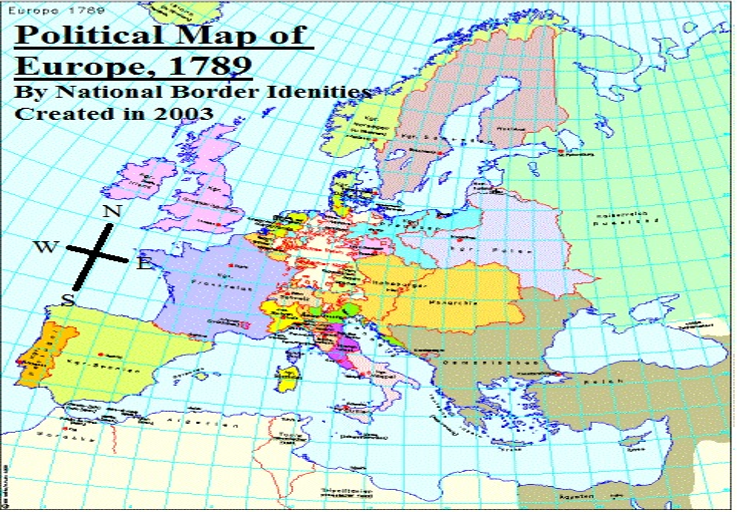
Historical Political Map of Europe, 1789

Political Map of Northern Europe, Current
Border Change Over Time
As illustrated by the two political maps shown, the borders of Northern Europe have changed significantly. Perhaps the most prominent border is that of Sweden; as shown in map from 1789, Sweden used to expand over the current area of Finland. Also a noticeable change was the forming of Estonia, Latvia, and Lithuania. Previously this land was engulfed by Russia. Another difference from the 1789 map is the formation of Ireland. This land was covered by the United Kingdom, but now the UK controls only the northern part.
